Back to the main page Back to category Compasses and GPS
watch details
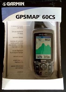
NEW GARMIN HIKING PORTABLE BACKPACKING GPS MAP 60CS MINT IN BOX
Estimated price for orientation: 229 $
Category: Compasses and GPS
Class:
Description Condition: New: A brand-new, unused, unopened, undamaged item in its original packaging (where packaging is applicable). Packaging should be the same as what is found in a retail store, unless the item is handmade or was packaged by the manufacturer in non-retail packaging, such as an unprinted box or plastic bag. See the seller's listing for full details. See all condition definitions- opens in a new window or tab ... Read moreabout the condition Type: GPS Model: GPS MAP 60CS Brand: GARMIN
MINT !!!!!! NEVER USED!!!!!! Product Description Enjoy the all-new features this waterproof Garmin handheld GPS has to offer. The electronic compass displays accurate directional readings while standing in place, and the Barometric sensor has an automatic pressure tend recording. Its 256-color TFT display (2-1/2 dia.) is sunlight-readable, making it much easier to see, and the faster processor with auto routing makes it much more fun to use. Features 56MB of internal memory for storing map details; permanent user data storage; outdoor calendar that lets you store each day's best hunting and fishing times; and a Geo-caching navigation mode. The GPSMap 60CS is packed with navigational features, but Garmin knows that a great device has to go beyond a simple color display to be the cream of the crop. With that, Garmin has upped the ante on this lightweight, rugged, waterproof unit, offering a 256-color, highly reflective display that provides easy viewing in almost any lighting condition, including bright sunlight. This transreflective TFT, 2.6-inch-diagonal screen provides excellent viewing while maximizing battery life (up to twenty hours with typical use).
The GPSMap 60CS packs GPS navigation into a compact, waterproof device. The GPSMap 60CS adds two premium features to the basic design of the less expensive 60C model: an electronic compass and a barometric altimeter, both crucial for highland adventures. These sensors, when combined with GPS technology, provide enhanced bearing and elevation readings. A barometric sensor with automatic pressure readings allows you to view changes in pressure for a set period of time. With the elevation computer, you can find current elevation, ascent/descent rate, minimum and maximum elevation, total ascent and descent, and average and maximum ascent and descent rate. The trip computer provides odometer, stopped time, moving average, overall average, total time, max speed, and more. Product Features All-purpose handheld 12-parallel-channel GPS+WAAS receiver with electronic compass and barometric altimeter Sunlight-readable, 256-color, 2.6-inch-diagonal transflective TFT display; rapid automatic route calculation 56 MB internal memory for storing map detail; supports both USB and serial port PC interfaces Includes geolocation games such as Virtual Maze, Nibbons, Geko Smak, Memory Race, and Gekoids Runs for 20 hours on 2 AA batteries; measures 2.4 x 6.1 x 1.3 inches (W x H x D); 1-year warranty Dimensions Size (LWH): 8.5 inches, 5.75 inches, 3.5 inches Weight: 3 pounds What's in the Box GPSMap 60CS receiver, basemap (Americas Recreational), MapSource Trip & Waypoint Manager CD, PC/USB interface cable, lanyard, belt clip, quick start guide, and owner's manual.
Description
| Condition: | New: A brand-new, unused, unopened, undamaged item in its original packaging (where packaging is applicable). Packaging should be the same as what is found in a retail store, unless the item is handmade or was packaged by the manufacturer in non-retail packaging, such as an unprinted box or plastic bag. See the seller's listing for full details. See all condition definitions- opens in a new window or tab ... Read moreabout the condition | Type: | GPS |
| Model: | GPS MAP 60CS | Brand: | GARMIN |
MINT !!!!!! NEVER USED!!!!!! Product Description Enjoy the all-new features this waterproof Garmin handheld GPS has to offer. The electronic compass displays accurate directional readings while standing in place, and the Barometric sensor has an automatic pressure tend recording. Its 256-color TFT display (2-1/2 dia.) is sunlight-readable, making it much easier to see, and the faster processor with auto routing makes it much more fun to use. Features 56MB of internal memory for storing map details; permanent user data storage; outdoor calendar that lets you store each day's best hunting and fishing times; and a Geo-caching navigation mode. The GPSMap 60CS is packed with navigational features, but Garmin knows that a great device has to go beyond a simple color display to be the cream of the crop. With that, Garmin has upped the ante on this lightweight, rugged, waterproof unit, offering a 256-color, highly reflective display that provides easy viewing in almost any lighting condition, including bright sunlight. This transreflective TFT, 2.6-inch-diagonal screen provides excellent viewing while maximizing battery life (up to twenty hours with typical use).
The GPSMap 60CS packs GPS navigation into a compact, waterproof device. The GPSMap 60CS adds two premium features to the basic design of the less expensive 60C model: an electronic compass and a barometric altimeter, both crucial for highland adventures. These sensors, when combined with GPS technology, provide enhanced bearing and elevation readings. A barometric sensor with automatic pressure readings allows you to view changes in pressure for a set period of time. With the elevation computer, you can find current elevation, ascent/descent rate, minimum and maximum elevation, total ascent and descent, and average and maximum ascent and descent rate. The trip computer provides odometer, stopped time, moving average, overall average, total time, max speed, and more. Product Features All-purpose handheld 12-parallel-channel GPS+WAAS receiver with electronic compass and barometric altimeter Sunlight-readable, 256-color, 2.6-inch-diagonal transflective TFT display; rapid automatic route calculation 56 MB internal memory for storing map detail; supports both USB and serial port PC interfaces Includes geolocation games such as Virtual Maze, Nibbons, Geko Smak, Memory Race, and Gekoids Runs for 20 hours on 2 AA batteries; measures 2.4 x 6.1 x 1.3 inches (W x H x D); 1-year warranty Dimensions Size (LWH): 8.5 inches, 5.75 inches, 3.5 inches Weight: 3 pounds What's in the Box GPSMap 60CS receiver, basemap (Americas Recreational), MapSource Trip & Waypoint Manager CD, PC/USB interface cable, lanyard, belt clip, quick start guide, and owner's manual.
The GPSMap 60CS packs GPS navigation into a compact, waterproof device. The GPSMap 60CS adds two premium features to the basic design of the less expensive 60C model: an electronic compass and a barometric altimeter, both crucial for highland adventures. These sensors, when combined with GPS technology, provide enhanced bearing and elevation readings. A barometric sensor with automatic pressure readings allows you to view changes in pressure for a set period of time. With the elevation computer, you can find current elevation, ascent/descent rate, minimum and maximum elevation, total ascent and descent, and average and maximum ascent and descent rate. The trip computer provides odometer, stopped time, moving average, overall average, total time, max speed, and more. Product Features All-purpose handheld 12-parallel-channel GPS+WAAS receiver with electronic compass and barometric altimeter Sunlight-readable, 256-color, 2.6-inch-diagonal transflective TFT display; rapid automatic route calculation 56 MB internal memory for storing map detail; supports both USB and serial port PC interfaces Includes geolocation games such as Virtual Maze, Nibbons, Geko Smak, Memory Race, and Gekoids Runs for 20 hours on 2 AA batteries; measures 2.4 x 6.1 x 1.3 inches (W x H x D); 1-year warranty Dimensions Size (LWH): 8.5 inches, 5.75 inches, 3.5 inches Weight: 3 pounds What's in the Box GPSMap 60CS receiver, basemap (Americas Recreational), MapSource Trip & Waypoint Manager CD, PC/USB interface cable, lanyard, belt clip, quick start guide, and owner's manual.