Back to the main page Back to category Compasses and GPS
watch details
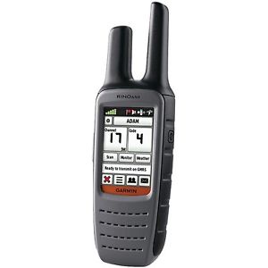
Garmin Rino 650 - Brand New - Ships Same Day!
Estimated price for orientation: 439 $
Category: Compasses and GPS
Class:
Description Condition: New: A brand-new, unused, unopened, undamaged item in its original packaging (where packaging is applicable). Packaging should be the same as what is found in a retail store, unless the item is handmade or was packaged by the manufacturer in non-retail packaging, such as an unprinted box or plastic bag. See the seller's listing for full details. See all condition definitions- opens in a new window or tab ... Read moreabout the condition Brand: GARMIN MPN: 010-00928-01 UPC: Does not apply
See Your SurroundingsThe device comes with a worldwide basemap with shaded relief, so you can navigate anywhere with ease. Adding more maps is easy with Garmin's wide array of detailed topographic, marine and road maps. With its microSD™ card slot, Rino 650 lets you load TOPO U.S. 24k maps and hit the trail or plug in BlueChart g2 preloaded cards for a great day on the water. The device also supports BirdsEye Satellite Imagery (subscription required), that lets you download satellite images to your device and integrate them with your maps. In addition, Rino 650 is compatible with Custom maps, free software that transforms paper and electronic maps into downloadable maps for your device.Find Your FriendsRino 650’s unique Position Reporting capability lets you send your exact location to other Rino users so they can see it on their map page. Plus, improved audio performance means it’s easy to communicate with any other conventional FRS/GMRS radio in the area. It can be useful in an emergency, or just a handy way to keep tabs on your hunting party, hiking partner, family or friends. Stay in TouchWith plenty of transmit power, Rino 650 also lets you send unit-to-unit text messages to other Rino users in your area – it's ideal for loud or windy conditions, or just when you don't want to disturb the wildlife. It also lets you share your waypoints, tracks, routes and geocaches wirelessly with other compatible Garmin handheld devices. View Weather Watches and WarningsFor added safety, Rino 650 features a built-in NOAA weather radio that can help you avoid hazardous weather. The radio supports Specific Area Message Encoding, which allows you to see National Weather Service warnings and watches displayed county-by-county on the map screen. Plan Your Next TripTake charge of your next adventure with BaseCamp™, software that lets you view and organize maps, waypoints, routes, and tracks. This free trip-planning software even allows you to create Garmin Adventures that you can share with friends, family or fellow explorers. BaseCamp displays topographic map data in 2-D or 3-D on your computer screen, including contour lines and elevation profiles. It also can transfer an unlimited amount of satellite images to your device when paired with a BirdsEye Satellite Imagery subscription.Turn Your Computer Into a Base StationThe all-new BaseStation lets you turn your laptop (loaded with BaseCamp) into a field command center for tracking multiple Rino units. View real-time GPS information on the larger display of your computer with Rino serving as a router/antenna. And because it’s Garmin GPS-based, safer, more effective search and rescue operations are in your control, even where Internet and cell phone service isn’t.
Weathering the StormWeather any storm with Rino's built-in NOAA weather radio that helps you avoid hazardous weather. The radio displays county lines and storm watches/warnings on the map screen so you'll always be in the know...and safe.
Advanced Contact TrackingWhat's in a name? A lot when it comes to Rino. Now, you can track 2,000 points of information per contact. Plus, the track manager makes it easy for you to maintain and review who you've been tracking.
Improved NotesGone are the days of missing a note. Rino time stamps and records the notes you receive from contacts for later review, or forwarding.
DashboardsBring more functionality to your device with more dashboards in more places. View your elevation plot, coordinates, compass arrow and more on any page, at any time.
Multiple Personalities with Multiple ProfilesCustomize Rino to be as well-rounded as you. You can set up different profiles so you can quickly switch personalities based on what you're doing - hiking, driving or more. With Rino, you'll never miss a beat.
View Multiple ContactsStay with your group, even when they are far away. Rino lets you view multiple contacts on 1 screen, so even if you're far away, you can see where they are in relation to you. Plus, you can easily route to your friends or regroup if you need to.
Rugged GPS + RadioUses HotFix® and a high sensitivity receiver and quad helix antenna to acquire satellitesOffers an improved base map with Digital Elevation ModelOffers improved mapping support with access to TOPO U.S. 24k, BirdsEye Satellite Imagery, Garmin Custom Maps, City Navigator NT, BlueChart g2 and more (sold separately)Uses a universally accepted GPX file format to store your data and allow compatbility with your computerOffers innovative features like a 2.6" glove-friendly color touchscreen, barometric altimeter and 3-axis electronic compassAllows you to send unit-to-unit text messages (via radio signals) to other Rino users in the area as well as share your waypoints, tracks, routes and geocaches wirelesslyPhysical & PerformancePhysical dimensions 2.4" x 7.5" x 1.8" (6.0 x 19.0 x 4.5 cm) Display size, WxH 1.43" x 2.15" (3.6 x 5.5 cm); 2.6" diag (6.6 cm) Display resolution, WxH 160 x 240 pixels Display type 2.6" transflective, 65K color TFT Weight 11.3 oz (320 g) with battery pack Battery removable, rechargeable lithium-ion battery pack Battery life 14 hours (up to 18 hours with optional AA battery pack) Water rating IPX7 High-sensitivity receiver Interface high-speed USB and NMEA 0183 compatible Barometric altimeter Electronic compass Yes (tilt-compensated 3-axis) Transmit power 0.5 watts FRS, 2.0 watts GMRS (Canada), 5.0 watts, GMRS (US)
Maps & MemoryBasemap Ability to add maps Built-in memory 1.7 GB Accepts data cards microSD™ card (not included) Waypoints/favorites/locations 2000 Routes 200 Track log 10,000 points, 200 saved tracks
Outdoor FeaturesAutomatic routing (turn by turn routing on roads) Geocaching-friendly Hunt/fish calendar Sun and moon information Area calculation Picture viewer
Two-way Radio FeaturesFrequency band FRS and GMRS Channels 22 Squelch codes 38 (CTCSS); 83 (DCS) Range Up to 2 miles over FRS; up to 20 miles over GMRS (US); up to 13 km over GMRS (Canada) VOX (voice activation) Location reporting (send and receive GPS positions) Vibration alert NOAA weather radio
What's in the Box: Rino 650Lithium-ion battery packUSB cableAC chargerCarabiner clipManuals
Description
| Condition: | New: A brand-new, unused, unopened, undamaged item in its original packaging (where packaging is applicable). Packaging should be the same as what is found in a retail store, unless the item is handmade or was packaged by the manufacturer in non-retail packaging, such as an unprinted box or plastic bag. See the seller's listing for full details. See all condition definitions- opens in a new window or tab ... Read moreabout the condition | Brand: | GARMIN |
| MPN: | 010-00928-01 | UPC: | Does not apply |
See Your SurroundingsThe device comes with a worldwide basemap with shaded relief, so you can navigate anywhere with ease. Adding more maps is easy with Garmin's wide array of detailed topographic, marine and road maps. With its microSD™ card slot, Rino 650 lets you load TOPO U.S. 24k maps and hit the trail or plug in BlueChart g2 preloaded cards for a great day on the water. The device also supports BirdsEye Satellite Imagery (subscription required), that lets you download satellite images to your device and integrate them with your maps. In addition, Rino 650 is compatible with Custom maps, free software that transforms paper and electronic maps into downloadable maps for your device.Find Your FriendsRino 650’s unique Position Reporting capability lets you send your exact location to other Rino users so they can see it on their map page. Plus, improved audio performance means it’s easy to communicate with any other conventional FRS/GMRS radio in the area. It can be useful in an emergency, or just a handy way to keep tabs on your hunting party, hiking partner, family or friends. Stay in TouchWith plenty of transmit power, Rino 650 also lets you send unit-to-unit text messages to other Rino users in your area – it's ideal for loud or windy conditions, or just when you don't want to disturb the wildlife. It also lets you share your waypoints, tracks, routes and geocaches wirelessly with other compatible Garmin handheld devices. View Weather Watches and WarningsFor added safety, Rino 650 features a built-in NOAA weather radio that can help you avoid hazardous weather. The radio supports Specific Area Message Encoding, which allows you to see National Weather Service warnings and watches displayed county-by-county on the map screen. Plan Your Next TripTake charge of your next adventure with BaseCamp™, software that lets you view and organize maps, waypoints, routes, and tracks. This free trip-planning software even allows you to create Garmin Adventures that you can share with friends, family or fellow explorers. BaseCamp displays topographic map data in 2-D or 3-D on your computer screen, including contour lines and elevation profiles. It also can transfer an unlimited amount of satellite images to your device when paired with a BirdsEye Satellite Imagery subscription.Turn Your Computer Into a Base StationThe all-new BaseStation lets you turn your laptop (loaded with BaseCamp) into a field command center for tracking multiple Rino units. View real-time GPS information on the larger display of your computer with Rino serving as a router/antenna. And because it’s Garmin GPS-based, safer, more effective search and rescue operations are in your control, even where Internet and cell phone service isn’t.
Weathering the Storm
Advanced Contact Tracking
Improved Notes
Dashboards
Multiple Personalities with Multiple Profiles
View Multiple Contacts
Rugged GPS + RadioUses HotFix® and a high sensitivity receiver and quad helix antenna to acquire satellitesOffers an improved base map with Digital Elevation ModelOffers improved mapping support with access to TOPO U.S. 24k, BirdsEye Satellite Imagery, Garmin Custom Maps, City Navigator NT, BlueChart g2 and more (sold separately)Uses a universally accepted GPX file format to store your data and allow compatbility with your computerOffers innovative features like a 2.6" glove-friendly color touchscreen, barometric altimeter and 3-axis electronic compassAllows you to send unit-to-unit text messages (via radio signals) to other Rino users in the area as well as share your waypoints, tracks, routes and geocaches wirelesslyPhysical & Performance
Maps & Memory
Outdoor Features
Two-way Radio Features
What's in the Box: Rino 650Lithium-ion battery packUSB cableAC chargerCarabiner clipManuals
| Weather any storm with Rino's built-in NOAA weather radio that helps you avoid hazardous weather. The radio displays county lines and storm watches/warnings on the map screen so you'll always be in the know...and safe. |
| What's in a name? A lot when it comes to Rino. Now, you can track 2,000 points of information per contact. Plus, the track manager makes it easy for you to maintain and review who you've been tracking. |
| Gone are the days of missing a note. Rino time stamps and records the notes you receive from contacts for later review, or forwarding. |
| Bring more functionality to your device with more dashboards in more places. View your elevation plot, coordinates, compass arrow and more on any page, at any time. |
| Customize Rino to be as well-rounded as you. You can set up different profiles so you can quickly switch personalities based on what you're doing - hiking, driving or more. With Rino, you'll never miss a beat. |
| Stay with your group, even when they are far away. Rino lets you view multiple contacts on 1 screen, so even if you're far away, you can see where they are in relation to you. Plus, you can easily route to your friends or regroup if you need to. |
| Physical dimensions | 2.4" x 7.5" x 1.8" (6.0 x 19.0 x 4.5 cm) |
|---|---|
| Display size, WxH | 1.43" x 2.15" (3.6 x 5.5 cm); 2.6" diag (6.6 cm) |
| Display resolution, WxH | 160 x 240 pixels |
| Display type | 2.6" transflective, 65K color TFT |
| Weight | 11.3 oz (320 g) with battery pack |
| Battery | removable, rechargeable lithium-ion battery pack |
| Battery life | 14 hours (up to 18 hours with optional AA battery pack) |
| Water rating | IPX7 |
| High-sensitivity receiver | |
| Interface | high-speed USB and NMEA 0183 compatible |
| Barometric altimeter | |
| Electronic compass | Yes (tilt-compensated 3-axis) |
| Transmit power | 0.5 watts FRS, 2.0 watts GMRS (Canada), 5.0 watts, GMRS (US) |
| Basemap | |
|---|---|
| Ability to add maps | |
| Built-in memory | 1.7 GB |
| Accepts data cards | microSD™ card (not included) |
| Waypoints/favorites/locations | 2000 |
| Routes | 200 |
| Track log | 10,000 points, 200 saved tracks |
| Automatic routing (turn by turn routing on roads) | |
|---|---|
| Geocaching-friendly | |
| Hunt/fish calendar | |
| Sun and moon information | |
| Area calculation | |
| Picture viewer | |
Two-way Radio Features
| Frequency band | FRS and GMRS |
|---|---|
| Channels | 22 |
| Squelch codes | 38 (CTCSS); 83 (DCS) |
| Range | Up to 2 miles over FRS; up to 20 miles over GMRS (US); up to 13 km over GMRS (Canada) |
| VOX (voice activation) | |
| Location reporting (send and receive GPS positions) | |
| Vibration alert | |
| NOAA weather radio | |