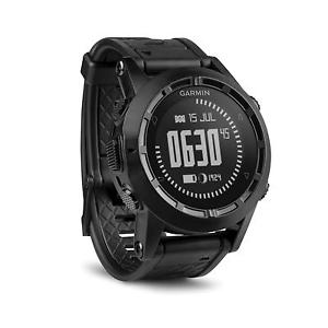
Rugged GPS Navigator in a tactical design High-sensitivity GPS positioning with automatic calibrating altimeter, barometer and 3-axis compass Bold and rugged all-black stylish design. It's scratch-resistant, curved lens is rugged and prevents reflection Negative mode liquid crystal display with green LED TracBack® reverses the track log to navigate back to your starting point Mark up to 1,000 waypoints and store up to 10,000 track points The field-ready tactix is a high-sensitivity GPS navigator plus ABC watch packed with features to securely explore the great outdoors. Inside, it’s an altimeter, barometer, 3-axis compass and tracker with 1,000 waypoints, 10,000 track points and TracBack capabilities. Outside, it is waterproof (to 50 meters), matte black and non-reflective with a green LED backlight that won’t flare out night vision. Plan, Navigate, Track tactix lets you create routes, record up to 1,000 waypoints and record GPS breadcrumb trails on the move (tracklogs). Navigate to coordinates, along a track or route, toward waypoints or along any other selected bearing. The TracBack function guides you back along a previously recorded tracklog so you can easily find your way to the campsite, trailhead or safety of a vehicle, even in challenging conditions. Plan trips and share adventures with friends and family using ™ and . tactix is equipped with both ANT+™ capabilities and Bluetooth® to wirelessly share tracks, waypoints and routes with other compatible Garmin devices or smartphones. Altimeter, Barometer and Compass tactix is equipped with ABC sensors (altimeter, barometer and compass) to provide relevant real-time information. The built-in altimeter provides elevation data to accurately monitor ascent and descent, while the barometer can be used to predict weather changes by showing short-term trends in air pressure. The 3-axis electronic compass keeps your bearing whether you’re moving or not. tactix auto-calibrates its ABC sensors using its GPS receiver and also auto sets the time based on location. For an extremely accurate temperature reading, pair it with our ™ external temperature sensor. Measure Performance tactix provides real-time performance data, such as distance, pace, cadence and calories, helping you keep track of your progress during and after your adventures. tactix is compatible with our heart rate monitor, speed/cadence bike sensor and foot pod — for indoor or outdoor use. Built to Endure the Roughest Conditions tactix combines a strong housing to survive shocks with a mineral glass lens to resist scratching. It boasts a large LCD display with a green LED backlight and a robust polyurethane wristband. It’s waterproof to 50 meters and has a battery life of up to 50 hours in GPS mode (depends on settings) and up to 5 weeks in watch mode. Tactical-Inspired The all-black, rugged and durable ABC plus GPS-enabled tactix was inspired by the strict design requirements mandated by Tactical units for the gear they use in the field. This bold all-black watch is stealthy, yet stylish. Its scratch-resistant, curved lens is rugged and prevents reflection. The Jumpmaster mode is invaluable to airborne operations. The green backlight won’t compromise your position or your vision (and won’t flare out night-vision goggles). More Than an Ordinary Watch tactix includes sun/moon information and a hunt/fish calendar in addition to basic watch functions such as alarms, tones, vibration alerts, a timer, stopwatch and world clock with the ability to display several times zones at once. It even allows you to control our ™ and ™ action cameras. | Physical & Performance: | | Unit dimensions, WxHxD | 4.9 x 4.9 x 1.7 cm | | Display size, WxH | 1.2” (3.1 cm) diameter | | Display resolution, WxH | 70 x 70 pixels | | Display type | Transflective, monochrome LCD (negative mode-black) | | Weight | 82 g | | Battery | Rechargeable lithium-ion | | Battery life | Up to 50 hours (GPS mode); 3 weeks (sensor mode); 5 weeks (watch mode) | | | 5 ATM | | Floats | No | | High-sensitivity receiver | Yes | | Interface | USB |
| Maps & Memory: | | Basemap | Yes | | Preloaded maps | No | | Ability to add maps | No | | Built-in memory | 20 MB | | Accepts data cards | No | | Waypoints/favorites/locations | 1000 | | Routes | 50 | | Track log | 10,000 points, 100 saved tracks |
| Features & Benefits: | | Automatic routing (turn by turn routing on roads) | No | | Electronic compass | Yes (tilt-compensated 3-axis) | | Touchscreen | No | | Barometric altimeter | Yes | | Camera | No | | | Yes (Paperless) | | | No | | Photo navigation (navigate to geotagged photos) | No | | Hunt/fish calendar | Yes | | Sun and moon information | Yes | | Tide tables | No | | Area calculation | Yes | | Custom POIs (ability to add additional points of interest) | Yes | | Unit-to-unit transfer (shares data wirelessly with similar units) | Yes | | Picture viewer | No | | Garmin Connect™ compatible (online community where you analyze, categorize and share data) | Yes | | Additional | Watch functions: time, date, alarm, timer, chronograph, chimes and vibrationFitness functions include: user profiles for running and cycling, Auto Pause®, Auto Lap®, alerts, customizable data fields such as heart rate, distance, pace, calories, laps, cadence and more Jumpmaster feature for experienced skydivers, particularly those in the military. It follows military guidelines for calculating a jumpmaster's high altitude release point (HARP), and can auto-detect when you have jumped to begin navigating toward the desired impact point (DIP) using the barometer and electronic compass. This USB mass storage device is compatible with Windows® XP or newer and Mac® OS X 10.4 or later. |
|