Back to the main page Back to category Compasses and GPS
watch details
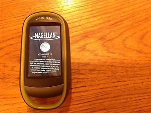
Magellan eXplorist 610
Estimated price for orientation: 320 $
Category: Compasses and GPS
Class:
Description Brand: Magellan Model: eXplorist 610 UPC: 763357124859
Used a handful of times. Works well, accurate and easy to use. I like the camera and the micro card slot to expand memory!Core Outdoor NavigationRugged and waterproof, the eXplorist combines high sensitivity GPS reception with aesthetic mapping and accurate navigation. Find your way using more than 30 navigational data fields. Create waypoints, record tracks, and route from point to point.Experience RecordingIntegrated 3.2 mega-pixel camera, microphone, and speaker enables outdoor enthusiasts to record geo-referenced images and voice notes. Relive your outdoor adventures on the device, on your computer, or share with others on various online communities.Superior Maps with 3D Perspective ViewThe eXplorist series packs some of the most accurate maps into the palm of your hand. The World Edition map allows for 2D or 3D viewing angles and covers the globe with details roads and land use areas. Summit Series is a new breed of topographic outdoor maps covering various regions with high level of detail. City Series will add turn-by-turn routing to your handheld GPS receiver.3.0" Touch Screen and Button ControlsThe best of both worlds, the eXplorist combines the user friendliness of a touch screen with the reliability of two customizable hard buttons. Program the hard buttons to your two favorite or most used functions and ensure quick reaction while wearing gloves or in just in a rush.Paperless GeocachingDownload and view more than 20 unique characteristics of each cache and view, search, filter on the device. Details include name, location, description, hider, size, difficulty, terrain, hint, and recent logs created by other geocachers.16 Hours of Battery LifePowered by two AA batteries, the eXplorist will last up to 16 hours under normal conditions. To help conserve power, use the suspend mode to turn off the device but maintain GPS tracking. You can also adjust power management settings to your preference.OneTouch™ MenuMagellan’s award winning OneTouch™ favorites menu is now on our handheld devices. It provides instant access to bookmarks of your favorite places. Set your home, camp, and car. Easily re-assign a new location for each new adventure. 12 customizable icons to create personalized searches, save unique locations, or assign quick access to your favorite screens3-axis Electronic Compass & Barometric AltimeterAlways know exactly where you are going, which direction is north, and your accurate altitude about sea level with built-in sensors. Know the direction to the geocache while standing still. Measure barometric pressure over time to track changing weather conditions. Use a number of different digital compasses to always understand your cardinal directions.World Edition Pre-loaded MapThe World Edition includes a complete road network in United States, Canada, Western Europe, and Australia and major roads throughout the rest of the world that provides cartographic orientation in almost any location. This unique preloaded map also includes water features, urban and rural land use, and a realistic shaded relief background.Summit Series CanadaSummit Series Canada is highly detailed topographic map based on 1:50,000 scale source maps. The map includes contour lines, land use areas, trails, waterways, and points of interest. Locate the nearest trailhead. Search nearest bike shops, fuel stations, or potable water source. Navigate safely in 3D perspective view while knowing the boundaries between private and public lands.VantagePointeXplorist users can use Magellan’s free VantagePoint PC application to view all your maps, waypoints, geocaches, trails and routes in one, easy-to-use application. Analyze your maps in 3D - turn, tilt, and "fly through" the terrain with the touch of the mouse. Create custom routes and mark waypoints with images, sounds and description messages.Navionics® Map CompatibilityNavionics is a world of products that enhance your enjoyment on and off your boat. Simply purchase a Navionics Gold Chart, HotMaps® Premium, or FishN' Chip Region (sold separately) and plug the SD Card into the eXplorist 510, 610 or 710.
Description
| Brand: | Magellan | Model: | eXplorist 610 |
| UPC: | 763357124859 |
Used a handful of times. Works well, accurate and easy to use. I like the camera and the micro card slot to expand memory!Core Outdoor NavigationRugged and waterproof, the eXplorist combines high sensitivity GPS reception with aesthetic mapping and accurate navigation. Find your way using more than 30 navigational data fields. Create waypoints, record tracks, and route from point to point.Experience RecordingIntegrated 3.2 mega-pixel camera, microphone, and speaker enables outdoor enthusiasts to record geo-referenced images and voice notes. Relive your outdoor adventures on the device, on your computer, or share with others on various online communities.Superior Maps with 3D Perspective ViewThe eXplorist series packs some of the most accurate maps into the palm of your hand. The World Edition map allows for 2D or 3D viewing angles and covers the globe with details roads and land use areas. Summit Series is a new breed of topographic outdoor maps covering various regions with high level of detail. City Series will add turn-by-turn routing to your handheld GPS receiver.3.0" Touch Screen and Button ControlsThe best of both worlds, the eXplorist combines the user friendliness of a touch screen with the reliability of two customizable hard buttons. Program the hard buttons to your two favorite or most used functions and ensure quick reaction while wearing gloves or in just in a rush.Paperless GeocachingDownload and view more than 20 unique characteristics of each cache and view, search, filter on the device. Details include name, location, description, hider, size, difficulty, terrain, hint, and recent logs created by other geocachers.16 Hours of Battery LifePowered by two AA batteries, the eXplorist will last up to 16 hours under normal conditions. To help conserve power, use the suspend mode to turn off the device but maintain GPS tracking. You can also adjust power management settings to your preference.OneTouch™ MenuMagellan’s award winning OneTouch™ favorites menu is now on our handheld devices. It provides instant access to bookmarks of your favorite places. Set your home, camp, and car. Easily re-assign a new location for each new adventure. 12 customizable icons to create personalized searches, save unique locations, or assign quick access to your favorite screens3-axis Electronic Compass & Barometric AltimeterAlways know exactly where you are going, which direction is north, and your accurate altitude about sea level with built-in sensors. Know the direction to the geocache while standing still. Measure barometric pressure over time to track changing weather conditions. Use a number of different digital compasses to always understand your cardinal directions.World Edition Pre-loaded MapThe World Edition includes a complete road network in United States, Canada, Western Europe, and Australia and major roads throughout the rest of the world that provides cartographic orientation in almost any location. This unique preloaded map also includes water features, urban and rural land use, and a realistic shaded relief background.Summit Series CanadaSummit Series Canada is highly detailed topographic map based on 1:50,000 scale source maps. The map includes contour lines, land use areas, trails, waterways, and points of interest. Locate the nearest trailhead. Search nearest bike shops, fuel stations, or potable water source. Navigate safely in 3D perspective view while knowing the boundaries between private and public lands.VantagePointeXplorist users can use Magellan’s free VantagePoint PC application to view all your maps, waypoints, geocaches, trails and routes in one, easy-to-use application. Analyze your maps in 3D - turn, tilt, and "fly through" the terrain with the touch of the mouse. Create custom routes and mark waypoints with images, sounds and description messages.Navionics® Map CompatibilityNavionics is a world of products that enhance your enjoyment on and off your boat. Simply purchase a Navionics Gold Chart, HotMaps® Premium, or FishN' Chip Region (sold separately) and plug the SD Card into the eXplorist 510, 610 or 710.