Back to the main page Back to category Compasses and GPS
watch details
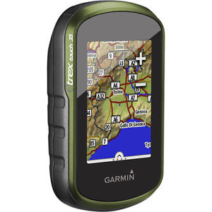
Garmin eTrex Touch 35 GPS Outdoor Handheld Navigator TopoActive Europe Maps
Estimated price for orientation: 270 $
Category: Compasses and GPS
Class:
Description Condition: New: A brand-new, unused, unopened, undamaged item in its original packaging (where packaging is applicable). Packaging should be the same as what is found in a retail store, unless the item is handmade or was packaged by the manufacturer in non-retail packaging, such as an unprinted box or plastic bag. See the seller's listing for full details. See all condition definitions- opens in a new window or tab ... Read moreabout the condition Brand: GARMIN MPN: Does Not Apply UPC: Does not apply
Plan Your Next TripTake charge of your next adventure with BaseCamp, software that lets you view and organize maps, waypoints, routes and tracks. This trip-planning software even allows you to create Garmin Adventures that you can share with friends, family or fellow explorers. BaseCamp displays topographic map data in 2-D or 3-D on your computer screen, including contour lines and elevation profiles. It also can transfer an unlimited amount of satellite images to your device when paired with a BirdsEye Satellite Imagery subscription.
Description
| Condition: | New: A brand-new, unused, unopened, undamaged item in its original packaging (where packaging is applicable). Packaging should be the same as what is found in a retail store, unless the item is handmade or was packaged by the manufacturer in non-retail packaging, such as an unprinted box or plastic bag. See the seller's listing for full details. See all condition definitions- opens in a new window or tab ... Read moreabout the condition | Brand: | GARMIN |
| MPN: | Does Not Apply | UPC: | Does not apply |
Plan Your Next TripTake charge of your next adventure with BaseCamp, software that lets you view and organize maps, waypoints, routes and tracks. This trip-planning software even allows you to create Garmin Adventures that you can share with friends, family or fellow explorers. BaseCamp displays topographic map data in 2-D or 3-D on your computer screen, including contour lines and elevation profiles. It also can transfer an unlimited amount of satellite images to your device when paired with a BirdsEye Satellite Imagery subscription.