Back to the main page Back to category Compasses and GPS
watch details
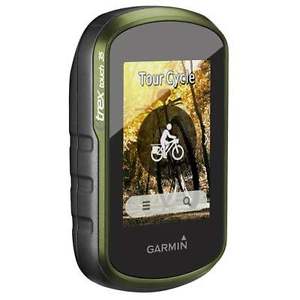
Garmin eTrex Touch 35 Handheld Hiking GLONASS & GPSsatellite 3axis 010-01325-10
Estimated price for orientation: 300 $
Category: Compasses and GPS
Class:
Description Condition: New other (see details): A new, unused item with absolutely no signs of wear. The item may be missing the original packaging, or in the original packaging but not sealed. The item may be a factory second or a new, unused item with defects. See the seller’s listing for full details and description of any imperfections. See all condition definitions- opens in a new window or tab ... Read moreabout the condition Brand: Garmin Type: Handheld MPN: 010-01325-10
The next iteration in Garmin's tried-and-true eTrex GPS series. The Touch 35 features a colour touchscreen, a 3-axis electronic compass and a preloaded basemap, all surrounded by a rugged, water-resistant housing. High-sensitivity GPS receiver with GLONASS support gives access to a huge range of satellites, resulting in faster, more accurate performance in heavy cover areas like canyons or dense forests. Added features like a barometric altimeter, ANT+ compatibility, and Bluetooth Smart compatibility make it a simple, intuitive, and reliable device for geocaching, meeting fitness goals, or supplementing your map and compass duo.Large colour touchscreen display makes it easy to zoom in and out of maps.GLONASS supported GPS receiver is fast, accurate, and consistent.HotFix satellite prediction for quick acquisition and good signal lock.Activity profiles let you customize data fields for activities like climbing, biking and hiking, and make it easy to switch between them.3-axis tilt-compensated compass shows your heading even when standing still, without holding it level.Barometric altimeter for hyper-accurate analysis.ANT+ compatibility opens up the ability to use many fitness sensors, such as heart rate straps.Bluetooth Smart compatible, so it can interact with many Garmin devices and sensors, and can receive notifications from compatible smart devices.Capable of turn-by-turn routing when paired with road maps (road map not included).Pre-loaded with 250,000 worldwide geocaches from geocaching.com4GB of internal memory.MicroSD slot for even more expanded memory (card not included).Compatible with free BaseCamp software, which displays topographic maps with contour lines and elevation profiles in 2-D or 3-D on your computer screen, and lets you view and organize maps, waypoints, routes and tracks.16 hours of battery life takes you pretty much anywhere.Takes 2 AA batteries (not included).Works with a wide range of eTrex mounts (sold separately) for use on bikes, boats and more.Weight 159g (Green) Ideal for Travel (Green) Display dimensions 5.5 x 3.6cm Dimensions 10.3 x 5.8 x 3.3cm IP X7 (Green) Built-in memory 4GB (Green) Countdown timer Yes (Green) Stopwatch Yes (Green) Display type Transflective colour TFT touchscreen (Green) 2000 (Green) Yes (Green) Metric/imperial units format Yes (Green) Interface USB and Wireless (Green) Not compatible (Green) Yes (Green) Yes (Green) Data card microSD card (not included) (Green) Battery power indicator Yes (Green) Tide tables Yes (Green) Track log 10,000 points, 200 saved tracks (Green) Area calculation Yes (Green) Low battery warning Yes (Green) Yes (Green) Not compatible (Green) Yes (Green) Yes (Green) Heart rate monitor Sold separately (Green) Touch screen Yes (Green) Yes (Green) Yes (Green) Distance/time alarm Yes (Green) Wireless sync to computer Yes (Green) Floats No (Green) Interval training No (Green) Button lock Yes (Green) Bluetooth Yes (Green) Batteries 2 AA (not included) (Green) Routes 200 (Green) Haptic feedback No (Green) Yes (Green) Yes (Green) No (Green) Not compatible (Green) Battery life 16 h (Green) Yes (Green) Yes (Green) Chest strap Sold separately (Green) Made in Taiwan (Green)
Description
| Condition: | New other (see details): A new, unused item with absolutely no signs of wear. The item may be missing the original packaging, or in the original packaging but not sealed. The item may be a factory second or a new, unused item with defects. See the seller’s listing for full details and description of any imperfections. See all condition definitions- opens in a new window or tab ... Read moreabout the condition | Brand: | Garmin |
| Type: | Handheld | MPN: | 010-01325-10 |
The next iteration in Garmin's tried-and-true eTrex GPS series. The Touch 35 features a colour touchscreen, a 3-axis electronic compass and a preloaded basemap, all surrounded by a rugged, water-resistant housing. High-sensitivity GPS receiver with GLONASS support gives access to a huge range of satellites, resulting in faster, more accurate performance in heavy cover areas like canyons or dense forests. Added features like a barometric altimeter, ANT+ compatibility, and Bluetooth Smart compatibility make it a simple, intuitive, and reliable device for geocaching, meeting fitness goals, or supplementing your map and compass duo.Large colour touchscreen display makes it easy to zoom in and out of maps.GLONASS supported GPS receiver is fast, accurate, and consistent.HotFix satellite prediction for quick acquisition and good signal lock.Activity profiles let you customize data fields for activities like climbing, biking and hiking, and make it easy to switch between them.3-axis tilt-compensated compass shows your heading even when standing still, without holding it level.Barometric altimeter for hyper-accurate analysis.ANT+ compatibility opens up the ability to use many fitness sensors, such as heart rate straps.Bluetooth Smart compatible, so it can interact with many Garmin devices and sensors, and can receive notifications from compatible smart devices.Capable of turn-by-turn routing when paired with road maps (road map not included).Pre-loaded with 250,000 worldwide geocaches from geocaching.com4GB of internal memory.MicroSD slot for even more expanded memory (card not included).Compatible with free BaseCamp software, which displays topographic maps with contour lines and elevation profiles in 2-D or 3-D on your computer screen, and lets you view and organize maps, waypoints, routes and tracks.16 hours of battery life takes you pretty much anywhere.Takes 2 AA batteries (not included).Works with a wide range of eTrex mounts (sold separately) for use on bikes, boats and more.
| Weight | 159g (Green) |
|---|---|
| Ideal for | Travel (Green) |
| Display dimensions | 5.5 x 3.6cm |
| Dimensions | 10.3 x 5.8 x 3.3cm |
| IP X7 (Green) | |
| Built-in memory | 4GB (Green) |
| Countdown timer | Yes (Green) |
| Stopwatch | Yes (Green) |
| Display type | Transflective colour TFT touchscreen (Green) |
| 2000 (Green) | |
| Yes (Green) | |
| Metric/imperial units format | Yes (Green) |
| Interface | USB and Wireless (Green) |
| Not compatible (Green) | |
| Yes (Green) | |
| Yes (Green) | |
| Data card | microSD card (not included) (Green) |
| Battery power indicator | Yes (Green) |
| Tide tables | Yes (Green) |
| Track log | 10,000 points, 200 saved tracks (Green) |
| Area calculation | Yes (Green) |
| Low battery warning | Yes (Green) |
| Yes (Green) | |
| Not compatible (Green) | |
| Yes (Green) | |
| Yes (Green) | |
| Heart rate monitor | Sold separately (Green) |
| Touch screen | Yes (Green) |
| Yes (Green) | |
| Yes (Green) | |
| Distance/time alarm | Yes (Green) |
| Wireless sync to computer | Yes (Green) |
| Floats | No (Green) |
| Interval training | No (Green) |
| Button lock | Yes (Green) |
| Bluetooth | Yes (Green) |
| Batteries | 2 AA (not included) (Green) |
| Routes | 200 (Green) |
| Haptic feedback | No (Green) |
| Yes (Green) | |
| Yes (Green) | |
| No (Green) | |
| Not compatible (Green) | |
| Battery life | 16 h (Green) |
| Yes (Green) | |
| Yes (Green) | |
| Chest strap | Sold separately (Green) |
| Made in | Taiwan (Green) |